Fire Weather Information
Red Flag Warnings
Weather and climate play major roles in the development and spread of wildfires. Of the three major components making up a fire’s environment (Fuel, Weather, and Topography), weather is the most important, and it is continuously changing. Weather elements that play the largest role in wildfires are:
-
- Wind
- Relative Humidity/Atmospheric Moisture
- Temperature
- In addition drought, a result of certain weather conditions and climate, must be considered.
Weather conditions that contribute to wildfires can be measured and predicted. Fire agencies monitor weather conditions daily and use indexes and predictions to make decisions about how to fight fires (how many fire engines, aircraft, and firefighters may be needed if a new fire occurs), how to prevent new fires from igniting (land closures, land use restrictions, and power shutdowns). Residents and visitors to areas where wildfires are likely to occur should be aware of current and predicted weather conditions, and take additional actions to prepare their family, home, and community when risk is elevated.
WHAT IS A RED FLAG WARNING?
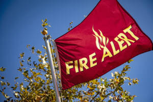 Fire Weather Watches and Red Flag Warnings are issued by the National Weather Service to notify the public and fire agencies in advance of critical weather patterns that may contribute to extreme fire danger and/or extreme fire behavior. A Red Flag Warning is issued for weather events which may contribute to extreme fire behavior and that will occur within 24 hours (or when these conditions are currently being observed). A Fire Weather Watch is issued when weather conditions could exist in the next 12-72 hours. A Red Flag Warning is the highest alert. During these times extreme caution is urged by all residents, because fires are more likely to ignite, and those that do are more likely to spread rapidly and be more difficult to control. A Fire Weather Watch is issued when fire danger is high or when Red Flag Warming conditions are predicted, but not yet observed.
Red Flag Warning conditions are typically related to wind events lasting at least 8 hours when: vegetation is already dry; annual grasses are cured; no rain has occurred in the last 24 hours; and “10-hour” fuels (dead vegetation 1/4 to 1/2 inch in diameter) have less than 6% moisture. Relative humidity and wind speed are the primary factors driving a Red Flag Warning declaration, and must fall into one of the following parameters:
| Relative Humidity | Wind Speed |
|---|---|
| Day, 29-42% and/or Night, 60-80% | 30+ mph |
| Day,19-28% and/or Night, 46-60% | 21+ mph |
| Day, 9-18% and/or Night, 31-45% | 12+ mph |
| Day, <9% and/or Night, <31% | 6+ mph |
Note that temperature is not a major factor in determining fire danger – hot days do not not trigger a Red Flag Warning unless low humidities and/or sustained, dry winds are also present.
Red Flag Warnings and Fire Weather Watches remain in effect through the expiration time noted in the forecast, or until canceled or upgraded.
Red Flag Warnings and Fire Weather Watches are posted on the California Fire Weather website.
WHAT SHOULD I DO DURING A RED FLAG WARNING?
Be prepared, and avoid activities that could spark a wildfire.
Personal Preparedness during a Red Flag Warning:
- Review your Wildfire Evacuation Checklist
- Prepare your home by enhancing your defensible space, and especially cleaning leaves from roofs, gutters, and around the base of walls.
- Ensure your family and pets are prepared, and keep your “Go Kits” nearby.
- Ensure your car has a full tank or fuel (or a full charge if electric!).
- Ensure your cell phone is charged, and monitor phones for emergency alerts.
- Keep hydrated – it’s usually warm and dry!
Activities to avoid during a Red Flag Warning
- Don’t use barbecues or fire-pits outdoors (especially charcoal or wood models, but also gas or propane)
- Don’t use a source of heat or open flame outdoors, including cooking, power tools (gas or electric), mowers.
- Don’t smoke outdoors
- Avoid driving or parking in dry grass or vegetation
- Avoid closed areas and be alert while visiting (open) public lands where wildfires might occur.
FIRE DANGER RATINGS
Fire danger ratings are measurements of weather and fuel conditions that help fire agencies predict how likely a fire may ignite, and how intensely and quickly it may burn. These ratings are determined daily during fire season by local fire agencies based on the National Fire Danger Rating System (NFDRS). These ratings are based on the probability of ignition; the effects of wind, slope and fuel; and the potential energy released by a fire in the given weather and fuels. A daily rating ranging from Low to Extreme fire danger is determined based on the worst case fire weather scenario during the hottest, driest part of the day on an open, south-facing slope.
Fire danger ratings may vary throughout the county and are used to determine whether land use restrictions will go into effect as well as how many firefighters should be available in case a wildfire does occur. Fire Danger Ratings describe the potential for fire to ignite and spread rapidly in a local area. Red Flag Warnings are a weather forecast used to predict a weather event in which fire will be difficult to control.
Resource credit: FIRESafe MARIN